|
Hazard Mapping Tool
 Our new application is ready to go and is called HzMAP! HzMAP is an online, GIS based, application that can used
to display items such as Confined Animal Feeder Operations and Tier II Chemical site locations along with information about those
locations. Other layers can be added based on the needs of the jurisdiction. The map, with its information, will be interactive and provide a visual display
for quick access and review. The application will stand-alone which will allow for flexibility in the display and content on a jurisdiction by jurisdiction
basis. Most importantly, it is very affordable as it does not require individual seat licenses, which makes it easy to share maps with all those involved
with emergency management planning. Our new application is ready to go and is called HzMAP! HzMAP is an online, GIS based, application that can used
to display items such as Confined Animal Feeder Operations and Tier II Chemical site locations along with information about those
locations. Other layers can be added based on the needs of the jurisdiction. The map, with its information, will be interactive and provide a visual display
for quick access and review. The application will stand-alone which will allow for flexibility in the display and content on a jurisdiction by jurisdiction
basis. Most importantly, it is very affordable as it does not require individual seat licenses, which makes it easy to share maps with all those involved
with emergency management planning.
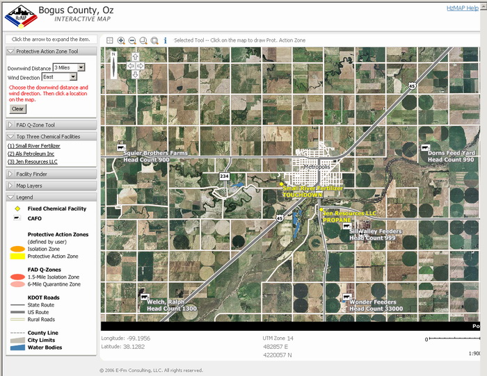
The application will have several key features for the users.
- Controlled access by username.
- Ability to select, zoom, and query.
- Site information on-screen.
- Create Protective Action Zones.
- Create Q-zones.
- Turn map layers on and off.
- Seamless access from anywhere in the world.
For a more thorough view of the application, call us, and we can arrange to do an on-line, hands-on, demonstration at your
convenience.
|
EFM Integrated, LLC


September 11, 2001
|